"Governing the road to China: Design, territory and data in the Peruvian Amazon" is published in Landscape Architecture Frontiers, volume one, issue six.
Kelly, A. S., & Pryor, M. R. (2013). Governing the road to China: Design, territory and data in the Peruvian Amazon. Landscape Architecture Frontiers, 1(6), 144-154.
Abstract:
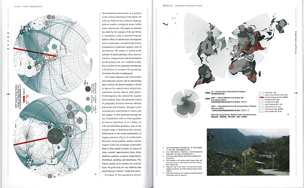
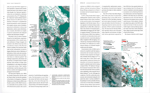
We are typically at a loss when designing for places without people. Frontier projects, including eco- and infrastructural tourism and rural development planning, operate where geography is either incredibly large (interoceanic highways) or in the very local, immediate work of NGOs. Here, "myths" of conservation discourse (poverty driving deforestation, biodiversity as merely scientific, etc.) frequently decouple the global-regional from the specifics of place. These densely mosaicked and homogenous landscapes present formidable barriers to conservation planning. Run at HKU as part of Harvard's South America Project, the work seeks a research agenda capable of narrating IIRSA highways' immense yet indirect role in deforestation. GIS serves as the primary tool for these narratives, deeply entrenched in the raw data and instruments of conservation science. This effort is described through speculations on GIS as a creative medium (not simply analysis) in data-poor regions, with precise control over complex, highly articulated surfaces and territories.
Keywords: environmental interpretation; IIRSA; GIS; political ecology; China-Latin American studies.
Posted by: Ashley Scott Kelly (Design for Conservation)