Launch Map Viewer
Launching map...


Design for Conservation

Design for Conservation: News 2019


Public Forum on Transborder Dawei Road Link

Thailand and Dawei Special Economic Zone: Road Link to Kilometer Zero. By Siamrath Thai News, 2019.

Thailand and Dawei Special Economic Zone: Road Link to Kilometer Zero

Date: 24 August 2019,
Time: 13:30,
Venue: Multi-function Room, 1st floor, Bangkok Art and Culture Centre.

Agenda:

Ashley Scott Kelly, Faculty of Architecture, The University of Hong Kong
Counter-assessment of impacts and history for the Dawei road link, 1995-2019.

Saw Frankie Abreu, Tenasserim River & Indigenous People Network (TRIP NET) and representatives from impacted communities
Voices from communities on the ground.

Teerachai Sancharoenkijthaworn, The Mekong Butterfly
Dawei Road Link: Hidden Cost of Impacts and Affected Community's Solving Mechanism/Measure.

Regan Pairojmahakij, World Wildlife Fund (WWF)
Biodiversity along the Dawei Road and measures to protect it.

Naruemon Thabchumpon, Faculty of Political Science, Chulalongkorn University
Transnational Politics, Local Communities and Human Security in Ethnic-controlled Area: A Case Study of the Dawei Road Link Project in Tanintharyi Region.

Luntharimar Longcharoen, independent researcher
Moderator

Hosted by SEM and Extra Territorial Obligations (ETOs) Watch

Abstract for Ashley's talk

Counter-assessment of impacts and history for the Dawei road link, 1995-2019
Ashley Scott Kelly, Faculty of Architecture, The University of Hong Kong

Environmental impact assessments bear the responsibility of assessing, negotiating, and ensuring accountability and deterrence of socioeconomic risks and environmental degradation. Most international standards call for cumulative impact analysis, which goes beyond the immediate physical impacts of construction and operation. However, for projects with long histories, here namely "projects" for the Dawei road link beginning in 1997, 2010, 2015, and 2019, what are most impactful are the ways these projects have incrementally, substantially, and sometimes violently rewritten these histories, albeit through the often technical languages of planning, engineering, ecology, and social science. In this talk, based on analysis of thousands of pages of company reports, over 150 unique sources, and high-resolution commercial satellite imagery, I look inside the development process for clues of how to better assess the complex past and future impacts of infrastructure on our environment. I summarize a two-decade history of the Dawei road corridor and argue that more rigorous tools and frameworks are necessary to combat the amnesia of infrastructure development, both in terms of historical narratives and technical knowledge. Strategic analysis and sustainability require longer-term studies, larger landscape extents, and deeper awareness of the development process.

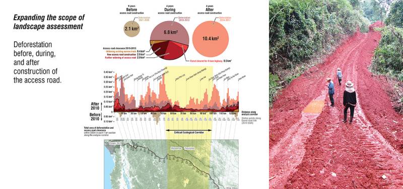
Slide: Expanding the scope of landscape assessment. By Ashley Scott Kelly, 2019.
Slide: Expanding the scope of wildlife assessment. By Ashley Scott Kelly, 2019.
Slide: Background research for History of the Dawei road link. By Ashley Scott Kelly, 2019.
Slide: Alignments and ESIA consistency. By Ashley Scott Kelly, 2019.
Slide: Construction activity and satellite image availability. By Ashley Scott Kelly, 2019.
Slide: What is a "project"? Does the Dawei road link "exist"?. By Ashley Scott Kelly, 2019.

Posted by: (Design for Conservation)

WWF releases Nature in Peril report

WWF releases new report, Nature in peril: The risk to forests and wildlife from the Dawei-Htee Khee Road, which places imminent threats to the ecological connectivity of Dawna-Tenasserim Landscape within a longer two-decade struggle between infrastructure and sustainability.

Nature in peril: The risk to forests and wildlife from the Dawei-Htee Khee Road, 2019.

This report is the fourth in a series of reports that have been published between 2015-2018.

The first report published in 2015, highlighted the need to consider information about ecosystem services, land-use change, and wildlife in the planning of the road and the broader land-use planning of the area (A Better road to Dawei—Protecting wildlife, sustaining nature, benefiting people). A design manual, published in 2016 as the second report, showcased design options for accommodating wildlife crossings and bio-engineering techniques for slope stabilization as well as alignment options to minimize deforestation and maximize social and environmental benefits (Design manual—Building a more sustainable road to Dawei).

Based on a request from the road developer in 2016 regarding the identification of wildlife movement patterns in the landscape, WWF worked with conservation organizations active in the area and regional mammal experts to identify critical crossing areas for mammals based on modelling (Wildlife crossing—Locating species’ movement corridors in Tanintharyi, published in 2016). This fourth report specifically brings together several years of work that has looked in-depth at what is at stake in this important ecological corridor system—a system that keeps key forested areas in Thailand and Myanmar connected and which the Dawei-Htee Khee road cuts across. This report outlines the history of the road and the newly approved 2018 Environmental and Social Impact Assessment (ESIA) of the Dawei-Htee Khee two-lane road project.

Authors:
Hanna Helsingen (WWF-Myanmar), Ashley Scott Kelly (University of Hong Kong), Grant Connette (Smithsonian Institution), Paing Soe (WWF-Myanmar), Nirmal Bhagabati (WWF-US), Regan Pairojmahakij (WWF-Greater Mekong), and Nilanga Jayasinghe (WWF-US)

Posted by: (Design for Conservation)

HKU Lecture by Alice Hughes: Biodiversity threats and patterns in the Asian tropics

HKU Landscape hosts a talk this Thursday by Dr. Alice Hughes from the landscape ecology group at Xishuangbanna Tropical Botanical Garden.

Biodiversity threats and patterns in the Asian tropics
Dr. Alice C. Hughes

Thursday, 9 May 2019
12:45 - 14:00
Venue: KB 419, Knowles Building
The University of Hong Kong

Alice is doing phenomenal work on quantifying the impacts of infrastructure development on habitat and biodiversity loss across Southeast Asia. She takes what we would consider a "landscape approach" by questioning the adequacy of existing infrastructure datasets to capture their true extent and impact. In strategy and effort, this goes well beyond the approaches of most recent global studies of its kind. Landscape Architecture in practice may play limited roles in most large-scale infrastructure development; however, these kinds of critical scientific approaches transcend scales and are increasingly important for building awareness when our disciplines undertake master plans in biodiversity-rich developing countries.

Talk abstract:

Despite their high levels of biodiversity and endemism, the Asian tropics are frequently forgotten in global discourse on tropical biodiversity loss. Here, in addition to mapping regional biodiversity patterns, I explore the main threats to the region’s biodiversity, evaluating their relative impact and outlining the prognosis for different areas and key ecosystems. Much of Asia has reached a point of almost no return for much of its native biodiversity, with rates of undocumented road building in many parts of the region (e.g., 90% of roads in central Kalimantan are unmapped) symptomatic of the rapid deforestation and exploitation of natural resources and native species in these regions. I also discuss priorities for action and implementation, approaches to setting these priorities, and the major barriers to implementing the necessary policy and management protocols to secure a future for the region’s biodiversity. Finally, I discuss scalable conservation approaches and the role of intergovernmental agreements in enforcing various regulations (e.g., SDGs, Aichi targets) to try to change the trajectory of this region and its threatened biota.

Lecture by Alice Hughes: Biodiversity threats and patterns in the Asian tropics, 2019.

Posted by: (Design for Conservation)

Studio Laos Video 2018

"Strategic Landscape Planning for the Greater Mekong" builds on five years of design-based experiential learning across mainland Southeast Asia by the Division of Landscape Architecture. This year, focusing on the regional impacts of China's Belt and Road Initiative in northern Laos, students spend one term engaging issues of development vis-à-vis landscape architecture to define problems and produce innovative planning proposals. During this process, students develop and deliver a 180-page research report to civil society and international NGOs, conduct fieldwork, individually design future scenarios through large-format maps, diagrams and models, and have their work juried by a cross-disciplinary panel of experts.

Promotional video for HKU Studio Laos, 2019.
HKU Studio Laos: Strategic Landscape Planning for the Greater Mekong, 2019.

Posted by: (Design for Conservation)