Environmental impact assessments bear the responsibility of assessing, negotiating, and ensuring accountability and deterrence of socioeconomic risks and environmental degradation. Most international standards call for cumulative impact analysis, which goes beyond the immediate physical impacts of construction and operation. However, for projects with long histories, here namely "projects" for the Dawei road link beginning in 1997, 2010, 2015, and 2019, what are most impactful are the ways these projects have incrementally, substantially, and sometimes violently rewritten these histories, albeit through the often technical languages of planning, engineering, ecology, and social science. Based on analysis of thousands of pages of company reports, over 150 unique sources, and high-resolution commercial satellite imagery, this project look inside the development process for clues of how to better assess the complex past and future impacts of infrastructure on our environment. Through constructing a novel two-decade history of the Dawei road corridor, I argue that more rigorous tools and frameworks are necessary to combat the amnesia of infrastructure development, both in terms of historical narratives and technical knowledge. Strategic analysis and sustainability require longer-term studies, larger landscape extents, and deeper awareness of the development process.
- Report: Kelly, A. S. (2019, under review). Design Review: Counter-assessment of impacts for the Dawei Road Link, 1995-2018 (Report). World Wide Fund for Nature (WWF) Myanmar. 198 pp.
- Speaker: Kelly, A. S. (2019). Counter-assessment of impacts and history for the Dawei road link, 1995-2019. Opening talk delivered at Thailand and Dawei Special Economic Zone: The Road Link to Kilometer Zero to a forum of academics, NGOs, civil society, community stakeholders, and public at Bangkok Art & Culture Centre (BACC). Bangkok, Thailand.
- Report: Helsingen, H., Kelly, A. S., Connette, G., Paing Soe, Bhagabati, N., Pairojmahakij, R., & Jayasinghe, N. (2019). Nature in peril: The risk to forests and wildlife from the Dawei-Htee Khee Road (Report). World Wide Fund for Nature (WWF) Myanmar. 51 pp.
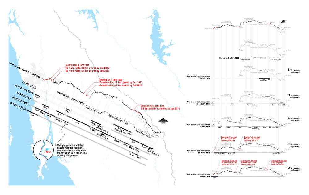
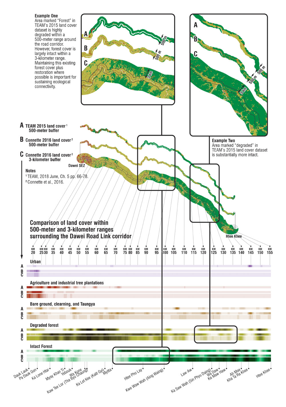
- Applied innovation: Geostatistical analysis of road construction using high-resolution commercial satellite imagery over five years along a 100+ kilometer corridor. This analysis contested the project's Environmental and Social Impact Assessment (ESIA) claim of the road's status as an "upgrade" project, using precise classification and quantification of clearance and construction activity, establishing new pre-construction baselines and innovative algorithms for categorization of various upgrading and widening construction activities.
- Applied innovation: Semi-automated analysis and graphic summary of satellite data availability from over 700 high-resolution (sub-meter) scenes to be certain that all possible remotely sensed evidence was acquired.
- Applied innovation: Adaptive visualization of a 45-page timeline built from semi-automated cataloguing of a 250-event history from nearly 300 references in over 180 unique source documents. For neutrality and to ease comprehension, these sources were presented in roughly 60 dominant voices (e.g., various governments, various tabloids, technical reports) in 20 categories, alongside the main stakeholders involved. Each of the 45 pages contains a map that is updated with its events' geospatial information, including impacted communities, road construction activity, and other important contextual information. A database was also compiled to automatically normalize Karen and Myanmar names of over 70 impacted villages in the project area, where some of them had over 10 spellings across the source documents. This automation allowed for the rapid revision of the timeline and presentation to stakeholders on three separate occasions during its creation, as well as multiple versions of history targeted to different stakeholder groups depending on the sources they trust.
- Applied innovation: Compilation of seven historical road alignments and interpolation of missing civil engineering coordinate systems used for design and impact evaluation, as well as geo-tagging and semi-automated mapping of 300 road construction photos (from a set of over 3000 photos).